

Ordnance Survey (OS) stands as Great Britain’s national mapping service, offering unparalleled accuracy and detail in geographic information. Established in 1791, OS has evolved into a cornerstone for navigation, planning, and exploration across the UK. Their commitment to providing comprehensive and precise mapping solutions distinguishes them from other providers.

A Comprehensive Range of Mapping Products
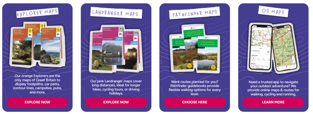
At Ordnance Survey, users can access a diverse array of mapping products tailored to various needs:
- Paper Maps: OS offers detailed paper maps, including the classic OS Explorer and OS Landranger series. These maps are ideal for outdoor activities such as hiking, cycling, and planning trips. They provide clear representations of terrain, footpaths, and points of interest.
- Digital Maps: For those seeking digital solutions, OS provides the OS Maps app, delivering interactive mapping and route planning capabilities. This app allows users to view and download maps for offline use, ensuring navigation remains uninterrupted even in areas with limited connectivity.
- Custom Maps: OS offers personalized maps, enabling users to create maps highlighting specific areas or routes. These custom maps are perfect for commemorating special events, planning unique journeys, or as thoughtful gifts.
- Educational Resources: For educators and students, OS provides a range of geography and GIS resources, bringing geography classes to life and enhancing learning experiences.
What Sets Ordnance Survey Apart
What distinguishes Ordnance Survey from other mapping services is its dedication to accuracy and detail. With over 230 years of experience, OS has meticulously mapped Great Britain, ensuring that their products are reliable and up-to-date. This extensive history and expertise provide users with a level of trust and confidence that is unparalleled in the industry.
Additionally, OS offers a range of data products and services, including geospatial data downloads, API products, and geospatial services. These offerings cater to businesses and organizations seeking to integrate detailed mapping data into their operations, further setting OS apart from other providers.
User-Friendly Online Experience
Navigating the Ordnance Survey website is straightforward, with clear categories and easy-to-use customization options. The platform allows users to select their preferred map type, area, and customization features, ensuring a seamless shopping experience. Whether you’re planning a hiking trip, cycling route, or simply exploring new areas, OS provides the tools and resources to assist in your journey.
Customer-Centric Services
Ordnance Survey offers free UK shipping on all orders over £50, enhancing the value of your purchase. Their customer service is responsive, ready to assist with any inquiries or customization requests, ensuring a satisfying experience from start to finish. Whether you need assistance with selecting the right map, understanding map features, or navigating the website, OS’s dedicated support team is available to help.
Conclusion
For those seeking detailed, accurate, and customizable mapping solutions, Ordnance Survey stands as a trusted and reliable choice. Their extensive range of products, commitment to quality, and user-friendly services make them a standout in the field of mapping and geographic information. Whether you’re an outdoor enthusiast, a business professional, or an educator, OS provides the tools and resources to navigate and understand the landscape of Great Britain with confidence.


